
The US East Coast is under a tropical storm warning with landfall forecast in North Carolina
MIAMI (AP) — A storm moving closer to the U.S. East Coast will deliver tropical storm conditions to North Carolina on Friday, the National Hurricane Center said.
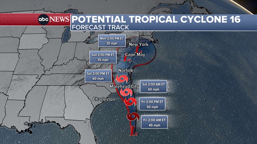
The storm was off the coast of South Carolina and North Carolina early Friday with top sustained winds of 50 mph (85 kph). A storm surge watch was in effect, with surges between 3 and 5 feet (0.9 to 1.5 meters) forecast for parts of North Carolina, the center reported.
As of Friday morning, the storm was located about 330 miles (530 kilometers) southeast of Charleston, South Carolina, and about 325 miles (525 kilometers) south Cape Hatteras, North Carolina, and moving north around 14 mph (22 kph), the center said.
Rainfall of 3 to 5 inches (7.6 to 12.7 centimeters), with localized amounts up to 7 inches (17.7 centimeters), was expected across eastern North Carolina and into southeast Virginia through Saturday, the center said.
Though the system had reached tropical storm strength, it was yet to be given a name and the center was still referring to it as Potential Tropical Cyclone Sixteen on Friday morning. The hurricane center defines a potential tropical cyclone as a disturbance posing a threat of tropical storm or hurricane conditions to land within 48 hours.
Meteorologist Maria Torres, a public affairs officer with the Miami-based center, said people along the Atlantic coast need to watch the storm’s progress, gather supplies and make preparations for its arrival.