
Vermont grapples with historic flooding as more rainstorms head for Northeast
Flood-ravaged areas in the northeastern United States could see even more rainfall on Thursday as communities try to recover from a historic deluge.
A severe weather system moving through the Plains and the Midwest is forecast to reach the Northeast by Thursday evening with scattered storms. That means potentially more rain from New York to Vermont, areas where the ground is already so saturated that it won't take much to cause more flooding.
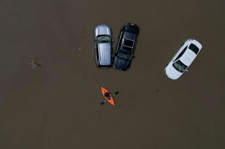
In Vermont, some areas had recorded up to 9 inches of rain over a 24-hour period by Tuesday afternoon as small creeks turned into raging rivers that swallowed roads in the worst flooding to hit the Green Mountain State since Tropical Storm Irene in 2011. Swift water rescue teams have rescued more than 100 people across Vermont since Sunday, though no injuries or deaths have been reported so far, according to officials.
The Winooski River, which runs through Vermont's capital, crested at 21.02 feet in Montpelier on Tuesday, its highest level since 1927. The river gradually receded, reaching below flood stage by Tuesday evening. The Wrightsville Dam, which forms a reservoir just outside Montpelier, was also beginning to recede and was not expected to breach the spillway, officials said.
The Lamoille River, running through northern Vermont, reached its highest level on record of 455.13 feet in the village of Jeffersonville on Tuesday.
PSC Holds Firm on LEAC Rates Amid WAPA's Deferred Fuel Cost Claims
As the Public Services Commission considered the Water & Power Authority’s request to exte...


